


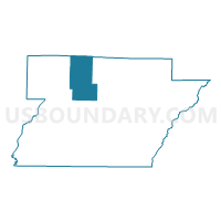
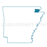
Crowley Voting District, Greene County, Arkansas
About
Outline

Summary
| Unique Area Identifier | 526581 |
| Name | Crowley Voting District |
| County | Greene County |
| State | Arkansas |
| Area (square miles) | 34.97 |
| Land Area (square miles) | 34.95 |
| Water Area (square miles) | 0.03 |
| % of Land Area | 99.93 |
| % of Water Area | 0.07 |
| Latitude of the Internal Point | 36.20623830 |
| Longtitude of the Internal Point | -90.62429200 |
Maps

Graphs
Select a template below for downloading or customizing gragh for Crowley Voting District, Greene County, Arkansas


Neighbors
Neighoring Voting District (by Name) Neighboring Voting District on the Map
- Breckenridge Voting District, Greene County, AR
- Cache & Wilson Voting District, Clay County, AR
- Clark Voting District, Clay County, AR
- Evening Shade Voting District, Greene County, AR
- Jones Voting District, Greene County, AR
- Sugar Creek Voting District, Greene County, AR
- Union Voting District, Greene County, AR
Top 10 Neighboring County Subdivision (by Population) Neighboring County Subdivision on the Map
- Union township, Greene County, AR (2,587)
- Breckenridge township, Greene County, AR (1,319)
- Sugar Creek township, Greene County, AR (729)
- Cache-Wilson township, Clay County, AR (477)
- Jones township, Greene County, AR (458)
- Crowley township, Greene County, AR (297)
- Clark township, Clay County, AR (193)
- Evening Shade township, Greene County, AR (41)
Top 10 Neighboring Unified School District (by Population) Neighboring Unified School District on the Map
- Paragould School District, AR (20,123)
- Greene County Technical School District, AR (18,658)
- Corning Public Schools, AR (7,141)
- Marmaduke School District, AR (3,835)